Showing posts with label rock art. Show all posts

Tuesday, January 23, 2024

Tlaloc

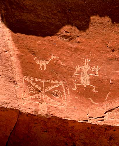
 I first came across Tlaloc, the Rain God, in an arroyo near Rincon in southern New Mexico.  The depiction of Tlaloc was on a rock face overlooking a hueco, a natural rock tank that collects rainwater and holds it long after the late summer monsoons.


According to rock art expert, Polly Schaafsma, Tlaloc representations with their rectangular heads and goggle eyes can be found throughout southern New Mexico wherever there are Jornada-style petroglyphs. The Rain God may have come along with the corn that found its way north from Mexico around two thousand years ago.

There are certainly mask-like designs everywhere I have found rock art, but the only other one I have seen that was clearly Tlaloc was high on a rock wall in Chaco Canyon. That unusually ornate example inspired me to offer a haiku in tribute:


Tlaloc, the Rain God,

Sometimes dons strange disguise

To walk among us


When I was in the process of redesigning the web site I maintained for displaying my rock art images I decided to create a Tlaloc-like figure as the favicon, the icon for the site that is displayed in the head of the browser. At the time, New Mexico was deep in a long drought and it occurred to me that each time a visitor clicked on the url of the site, the Rain God would be called. Perhaps not a guaranteed drought remedy, but it seemed like it was worth the gamble.

I closed down the rock art web site not long after moving to Albuquerque.  Mike Elek picked up the html code and images and preserved Sacred Places: New Mexico Rock Art as part of his vintage camera site, but the Tlaloc favicon did not go along. I then decided to reuse the Tlaloc favicon for my Everything Else website that I use for digital photography and various other purposes.  So, Tlaloc is still working to ameliorate our dry spells.

Monday, January 22, 2024

Endurance

 My recent visits to view the rock art at a couple sites that are part of the Petroglyph National Monument got me to thinking about the production and life span of images.  Indigenous people throughout the world created compelling visual records of important aspects of their cultures which in many cases have endured for thousands of years.  They did so using the simplest of tools along with patience and perseverance.  This petroglyph found at Crow Canyon, for instance, depicts important qualities of Navajo culture including their reflex-recurve bow design which they brought centuries ago from the far North.

By contrast, the millions of images produced daily using our technologically advanced methods and tools have life spans which can mostly be measured in hours, or even less.  Publishing them online or storing them on hard drives enhances longevity only an insignificant amount.  If a lasting impact is a goal, then trading a camera collection for a chisel and hammer would probably be a good choice.

Friday, January 19, 2024

Piedras Marcadas

Albuquerque had a fine sunny Wednesday, so I decided to take a hike through the Piedras Marcadas section of the Petroglyph National Monument.  Access to much of the site is limited by rope barriers, so photography is best undertaken with the help of a telephoto lens.  With my camera of the day, a No.1-A Folding Pocket Kodak Special, I had to limit most of my photo making to panels close to the trail.


The film was Fomapan 100, processed in HC-110b.  In the camera, FPP 120 to 116 spool adapters were used to hold the roll film firmly in place.  Eight rotations of the winder takes the film to the first frame.  Two-and-one-half rotations separates succeeding frames.

I also made quite a few shots of the rock art with my little digital Canon A1000 IS and I'll post some of those on my other blog.

Sunday, February 05, 2023

Hunting for Rock Art

 I went with a friend to visit the south end of the Petroglyph National Monument west of Albuquerque.  We were disappointed to find that the entire length of the east-facing slope is now blocked with a strand of steel cable and signs saying the area is closed to allow restoration of the vegetation.  That will likely reduce some foot traffic in the area, but does not offer any protection from vandalism as one can simply step over the wire.

Nevertheless, we honored the signs and stayed on the right side of the fence for the mile or two past the rock art panels.  I didn't want to return on the same path, so suggested we climb the slope past the end of the barrier and walk back along the canyon rim.  I was pleased to actually accomplish that given my rather poor mobility, and even more pleased to find a fine example of rock art along the rim consisting of the common concentric circles design accompanied by a turtle.  That made what had tuned into a five mile hike seem worthwhile.

We descended from the mesa down the gentler west slope to get back to my truck.  About half way down we came across this interesting rippled volcanic pavement that was laid down about 150,000 years ago by oozing eruptions along the Rio Grande Rift.

I felt unfatigued the next day and, suspecting I had not gotten any good quality images due in part to the excessive brightness of the noonday sun, I loaded the dog in the truck early in the morning and drove back to the mesa.  I returned to the mesa top along the easy west slope and was looking out atop the rimrock toward the mountains in about half an hour.

Turning north to follow the rim to the site of the petroglyph panel,  I stepped on a rock about knee height and suddenly felt the achilles tendon in my left leg stretch to the breaking point.  I ended up about ten feet downslope on my back.  My pinhole camera and the tripod were back where I had fallen. The Nikon F was still on its strap around my neck; I did not discover until later that the camera's rewind lever had snapped off.

Lying on my back and looking up at the blue New Mexico sky my first thought, of course, was to wonder if I would be crawling the mile back to the truck.  I was unable to flex my left foot, but I did manage to get myself into a standing position.  I found that I could walk -- very slowly -- by keeping the left foot flat.  I did have to scoot on my butt down one rocky slope to the sandy arroyo that parallels the west face of the mesa. Soon after we reached the arroyo a coyote started barking at me and the dog; it sounded a lot like laughter.

I think we reached the truck in about an hour.  Working the clutch was quite a challenge, but we made it home safely.  I ordered a replacement rewind lever from ebay for the Nikon F.  The leg will likely need some expert attention before I can get back to reshoot that rock art.

Thursday, April 21, 2022

Miles gone by

 I revisited the southernmost section of the Petroglyph National Monument.  It has been quite a while -- five years? ten? -- I'm not sure.  Memories of the place were sparked by a recent discovery of the photographic work of David Grant Noble who spent about forty years documenting ancient ruins and rock art of the Southwest. I'm not sure how I missed seeing Noble's excellent pictures sooner; I only became aware of them because the Maxwell Museum has scheduled an exhibit and artist talk in May. I was pleased to find a couple copies of Noble's book, In the Places of the Spirits, in the Albuquerque Library.


I was also delighted to find that Craig Childs has published several books since I read House of Rain twelve years ago. I decided to start catching up with Childs by reading Tracing Time; Seasons of Rock Art on the Colorado Plateau. Childs' approach to thinking about the ancient cultures of the Southwest is informed by familiarity with the academic research, but it is fundamentally the product of a unique personal immersion in the region's arid environment.


One of the topics Childs deals with in Tracing Time is the destruction of the ancient petroglyphs and pictographs.  In previous books he made the case for leaving any traces of past cultures completely undisturbed.  In this later work he suggests that those who deface and destroy ancient rock art are motivated by assertions of power and ownership which likely were behind similar destruction in ancient times.  It is not uncommon to find rock art panels with many layers of pecked or painted designs laid down over centuries.  The difference, of course, is that the destructive process has been greatly speeded up by exponential population growth along with greatly more efficient tools of destruction including firearms, spray paint and off-road vehicles.


Over the years I have maintained this blog I have at regular intervals acknowledged the idea that my photographic efforts would be enhanced by a more focused and deliberate approach, as opposed to just walking for miles and recording interesting sights I came across.  My journey back to Mesa Prieta yesterday was a concrete expression of that strategic option, brought about now by necessity.  I just can no longer wander for miles at a time to indulge an urge to record serendipitous discoveries.  I'll likely get back to National Petroglyph Monument again soon, and also hope to visit some of the many other rock art sites within a day's drive from Albuquerque.

I am also thinking I will try to narrow my choice of cameras to a few which are likely to produce reliable results to match my current photographic ambitions.  I exposed my recent roll of slightly expired Tri-X in my Mamiya C330, first on a walk beside the river, and then during my visit to the rock art site.  What I found in the process was that it would have been wise to quickly review the camera's manual before setting out as I encountered some problems with lens swapping which I was not prepared for. The C330 is the most versatile tlr available, but the controls are decidedly unintuitive.


Saturday, November 28, 2020

Kentmere 400 in XTOL 1:0

 My results with Kentmere 400 in undiluted Xtol were similar to what I got with HP5.  Both films liked morning light, particularly when there was some sky in the frame.  Bright mid-day sun and haze tended to flatten the mid-tones and emphasize grain in the skies.


So, I think the outcomes with these two fast films in xtol are pretty respectable, though it seems to me that they are not quite up the what I have gotten from PMK Pyro processing.  On the other hand, there are a lot of variables that complicate my assessment including my choices of camera, lens, exposure, time of day, photoshop adjustments, and scanner settings.  I'm also uncertain at this point about how well xtol ages compared to some of my other developers.  

Tuesday, December 11, 2018

Time Travel

When I want to get away from city streets I most often head east to the nearby foothills of the Sandia Mountains.  Several times a year I go a few miles in the opposite direction to Albuquerque's West Mesa.  My preferred objective in that area is the southern end of the long basalt escarpment which marks the boundary of the lava flows that emanated from a north-south fissure a couple miles to the west.  Only about a thousand feet separate the escarpment rim from the nearest housing developments, but the grid of streets and rooftops seems  distant and superficial because of the elevation and the intervening desert terrain.
    The distance between the basalt cliffs and the housing developments is perhaps better expressed in the dimension of time.  The suburbs only go back decades, while the lava cap of the mesa was laid down around 150,000 years ago.  Though that age predates human encroachment by well over 100,000 years it is still relatively young by geologic standards. The area between the small volcanic peaks and the escarpment's cliff face probably looks much as it did shortly after the lava cap was formed.


The slope below the rim is littered with great blocks of basalt which erosion has broken away from the face of the escarpment.  Spaces between the boulders are packed with dried tumbleweeds and other vegetation which often conceals deep clefts.  During the day one sees a few rabbits among the rock rubble while hawks glide noiselessly from one favored perch to another.  A pair of ravens will usually swoop in to voice their displeasure at any intruders.  Large rattlers are seen among the rocks frequently during the warm months, but in cold weather you can put your feet anywhere they will fit with only the risk of broken bones as a deterrent.


Although the litter and noise of the city is not far distant, little of that seems to reach the top of the cliffs.  The prevailing silence and the dramatic jumble of sharp edged boulders instill a sense of an unbroken continuum of Time.  Looking east you see the present and very recent past, while turning your gaze north, south or west shows you the world much as it was many millennia in the past.


Ancient rock art can be found all along the escarpment.  The images were laboriously pecked through the patina of the hard basalt to provide a contrasting design on the dark surface.  Most of the images date from the last few hundred years of occupation of the valley by Pueblo people, but a few go back thousands of years to the area's first inhabitants.  Later arrivals during the last couple centuries have added religious iconography, graffiti and bullet scars.

Sunday, July 02, 2017

Lost and Found

This kachina cult figure, possibly representing a bear shaman, is located in the Piedras Marcadas section of the Petroglyph National Monument on Albuquerque's west side..  Its creation likely dates back about three hundred years.


About six months ago, the bear shaman was lost, not to the world, but to me personally.  I had visited the the image several times since we first moved to Albuquerque in 2008 and photographed it with a couple of my old cameras.  Then, when I decided to revisit the rock art image and photograph  again about six months ago, I was unable to locate it.  I went back a half dozen times, but no luck; the image and its thousand-pound boulder seemed to have evaporated.  Something similar happened to me a couple times in the past twenty years that I have pursued an interest in ancient Southwest rock art.  I'm not sure exactly what goes on in my brain on these occasions; I'm usually pretty good at finding my way, even in unfamiliar or difficult terrain.  I knew the approximate location to within about a half-mile square around the site, but I just could not pin down the precise location.  How I finally relocated the rock art image seems as unlikely now as the image's strange disappearance.

The development of my interest in rock art more or less coincided with the beginning of collecting, restoring and using old film cameras.  One important resource in helping to get my old cameras working was a web site maintained by Rick Oleson who is extraordinarily talented at fixing old film cameras, as well as in illustrating his restorations with photos and drawings.  In addition to consulting Rick's site as needed, I also followed his photographic work on the Flickr photo sharing site.  One day recently, I noted that Rick's photo stream included some familiar looking rock art images.  It turned out that he had made a cross-country trip from his home in Kentucky that included a stop in Albuquerque and a visit to the Petroglyph National Monument.  And there among his images was a picture of the lost bear shaman.  It seemed an extraordinary coincidence.

Photo by Rick Oleson
Fortunately for me Rick's photograph included some important details of the terrain surrounding the rock art figure.  I made a sketch of his image paying particular attention to the profile of the escarpment behind the shaman figure, as well as some other rock art images which could just barely be made out among the jumble of rocks.  I returned to the Piedras Marcadas site with the sketch in my pocket and pretty confident of success, but it actually took me about an hour walking in and out of the several small canyons there to finally locate the shaman.  Perhaps I would have found the figure eventually on my own, but I certainly would never have imagined that I would locate it with the help of Rick Oleson.

Sunday, July 24, 2016

La Cieneguilla

I first visited the petroglyph site at La Cieneguilla shortly after we moved to Albuquerque in the Fall of 2008.  I was pleased sometime later when one of my shots of the Autumn foliage there was featured on the BLM web site for the area.  Recently, though, I noted that the picture has been reduced to a size which leaves much to the imagination, so I'm posting it here again.

The Cieneguilla site is a few miles south of the Santa Fe Airport at the west end of Galisteo Basin.

I drove up to La Cieneguilla again yesterday.  I was climbing up to the rimrock by 6:30, but it was already getting warm, and clambering over the rocks to get close to the petroglyphs was a challenge.  It is an effort worth making, however, because of the quantity and variety of rock art on display.  The site is particularly renowned for the large number of hunchback flute player images, but there are representatives of a great many of the designs found all along the valley of the Rio Grande and its tributaries.

Kokopeli

Procession


Whimsically recumbent Kokopeli


The Elk Hunter


I shot the Fuji 200 color in my Leica-copy FED 1g with the Jupiter-12 35mm lens and the matching wide-angle viewfinder.  My shutter repair seems to be holding up well, but I did get a little over-lap in a few frames.  Probably time for a more thorough cleaning.


I also exposed ten shots on TMAX 100 in one of my Kodak Duo Six-20 folders.  I have four of these 6x4.5 Kodaks which I like very much.  The one with the Anastigmat 4.5 lens and the Compur shutter works well.  I was planning on giving it some more exercise, but the heat and the terrain got the best of me. Next time, I'll take less gear and more water.


Sunday, July 17, 2016

La Bajada

I drove an hour north of Albuquerque yesterday to enjoy the morning's cool breeze and a sunrise walk at La Bajada.


La Bajada is best known today for the remnants of the old Route 66 alignment which snakes up over the escarpment above the Santa Fe River. That famous roadway, however, was preceded by older north/south routes including the colonial Spanish Camino Real which stretched all the way from Mexico City to Santa Fe. Before that, the local native people followed trails across the mesas and down the river canyon for thousands of years. Many petroglyphs can be seen on the slopes beside the eroded Bajada roadway which are thought to date mostly from the height of the Puebloan period between AD 1300-1600.


An acequia at the base of the escarpment carries Santa Fe River water to cultivated fields and pastures around the village of La Bajada.


Petroglyphs along the La Bajada route are mostly in the Rio Grande style.  Some like the small horned serpent figure are nearly identical to glyphs at La Rinconada forty miles to the south.


The Sandia Mountains east of Albuquerque can be seen in the far distance in the scene below.  In the foreground a large, cryptic design covers the upper surface of a large basalt boulder.  On the other side of the boulder there are a number of zoomorphic figures.


There are said to be petroglyphs all along the five-mile stretch of the Santa Fe river canyon between La Bajada and La Cieneguilla where there is a concentration of thousands of petroglyphs along the rimrock above a marshy area.

Perhaps when the weather cools in the Fall I'll try hiking to the top of La Bajada and down through the river canyon.

Saturday, April 09, 2016

Rock Art Morning

I enjoyed a morning outing to the Piedras Marcadas rock art site on the west side of Albuquerque thanks to being able to participate in a free photo workshop there conducted by Mark Bohrer.  I reaffirmed the fact that I am constitutionally unable to walk around taking pictures with a group of other photographers.  I did, however, appreciate Mark's fine introduction to the subject.  I was also inspired to look at the familiar site in a somewhat different way than I have in the past, and I explored some new ideas using color and filters that I hadn't got around to trying before.  Splendid weather and a fine experience.