Showing posts with label petroglyphs. Show all posts

Tuesday, January 23, 2024

Tlaloc

 I first came across Tlaloc, the Rain God, in an arroyo near Rincon in southern New Mexico.  The depiction of Tlaloc was on a rock face overlooking a hueco, a natural rock tank that collects rainwater and holds it long after the late summer monsoons.

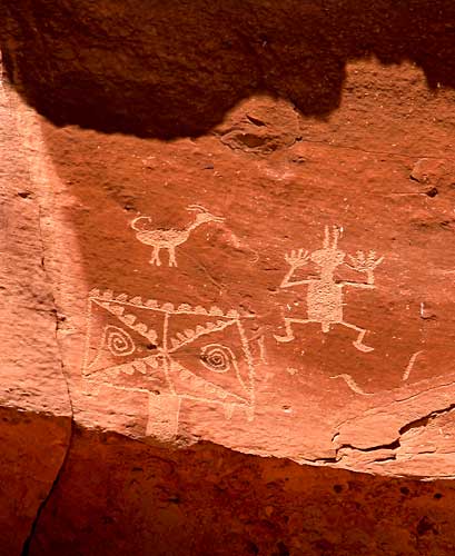
According to rock art expert, Polly Schaafsma, Tlaloc representations with their rectangular heads and goggle eyes can be found throughout southern New Mexico wherever there are Jornada-style petroglyphs. The Rain God may have come along with the corn that found its way north from Mexico around two thousand years ago.

There are certainly mask-like designs everywhere I have found rock art, but the only other one I have seen that was clearly Tlaloc was high on a rock wall in Chaco Canyon. That unusually ornate example inspired me to offer a haiku in tribute:


Tlaloc, the Rain God,

Sometimes dons strange disguise

To walk among us


When I was in the process of redesigning the web site I maintained for displaying my rock art images I decided to create a Tlaloc-like figure as the favicon, the icon for the site that is displayed in the head of the browser. At the time, New Mexico was deep in a long drought and it occurred to me that each time a visitor clicked on the url of the site, the Rain God would be called. Perhaps not a guaranteed drought remedy, but it seemed like it was worth the gamble.

I closed down the rock art web site not long after moving to Albuquerque.  Mike Elek picked up the html code and images and preserved Sacred Places: New Mexico Rock Art as part of his vintage camera site, but the Tlaloc favicon did not go along. I then decided to reuse the Tlaloc favicon for my Everything Else website that I use for digital photography and various other purposes.  So, Tlaloc is still working to ameliorate our dry spells.

Sunday, July 24, 2016

La Cieneguilla

I first visited the petroglyph site at La Cieneguilla shortly after we moved to Albuquerque in the Fall of 2008.  I was pleased sometime later when one of my shots of the Autumn foliage there was featured on the BLM web site for the area.  Recently, though, I noted that the picture has been reduced to a size which leaves much to the imagination, so I'm posting it here again.

The Cieneguilla site is a few miles south of the Santa Fe Airport at the west end of Galisteo Basin.

I drove up to La Cieneguilla again yesterday.  I was climbing up to the rimrock by 6:30, but it was already getting warm, and clambering over the rocks to get close to the petroglyphs was a challenge.  It is an effort worth making, however, because of the quantity and variety of rock art on display.  The site is particularly renowned for the large number of hunchback flute player images, but there are representatives of a great many of the designs found all along the valley of the Rio Grande and its tributaries.

Kokopeli

Procession


Whimsically recumbent Kokopeli


The Elk Hunter


I shot the Fuji 200 color in my Leica-copy FED 1g with the Jupiter-12 35mm lens and the matching wide-angle viewfinder.  My shutter repair seems to be holding up well, but I did get a little over-lap in a few frames.  Probably time for a more thorough cleaning.


I also exposed ten shots on TMAX 100 in one of my Kodak Duo Six-20 folders.  I have four of these 6x4.5 Kodaks which I like very much.  The one with the Anastigmat 4.5 lens and the Compur shutter works well.  I was planning on giving it some more exercise, but the heat and the terrain got the best of me. Next time, I'll take less gear and more water.


Sunday, July 17, 2016

La Bajada

I drove an hour north of Albuquerque yesterday to enjoy the morning's cool breeze and a sunrise walk at La Bajada.


La Bajada is best known today for the remnants of the old Route 66 alignment which snakes up over the escarpment above the Santa Fe River. That famous roadway, however, was preceded by older north/south routes including the colonial Spanish Camino Real which stretched all the way from Mexico City to Santa Fe. Before that, the local native people followed trails across the mesas and down the river canyon for thousands of years. Many petroglyphs can be seen on the slopes beside the eroded Bajada roadway which are thought to date mostly from the height of the Puebloan period between AD 1300-1600.


An acequia at the base of the escarpment carries Santa Fe River water to cultivated fields and pastures around the village of La Bajada.


Petroglyphs along the La Bajada route are mostly in the Rio Grande style.  Some like the small horned serpent figure are nearly identical to glyphs at La Rinconada forty miles to the south.


The Sandia Mountains east of Albuquerque can be seen in the far distance in the scene below.  In the foreground a large, cryptic design covers the upper surface of a large basalt boulder.  On the other side of the boulder there are a number of zoomorphic figures.


There are said to be petroglyphs all along the five-mile stretch of the Santa Fe river canyon between La Bajada and La Cieneguilla where there is a concentration of thousands of petroglyphs along the rimrock above a marshy area.

Perhaps when the weather cools in the Fall I'll try hiking to the top of La Bajada and down through the river canyon.

Friday, January 29, 2016

A couple more pinholes

I took the pinhole for a walk through the Piedras Marcadas rock art site on the west side of Albuquerque.  I was pleased with the pictures, though I don't know that I'll find a use for them in my current book project.


I had a great walk.  The sun was warm enough to make me regret wearing a winter coat.  Half way to the bear shaman glyph I was greeted by a coyote chorus.  Also saw lots of birds: road runners, doves and rock wrens.


I like the pinhole camera for the way its pictures reflect my feelings as I stand in front of the work of the ancient image makers.  I always have the sensation in such places that the great expanse of time since the images were made is really part of an unbroken continuum in which those original artists and I somehow exist simultaneously.

Tuesday, April 22, 2014

More from Crow Canyon

The Navajo people may have resided in the area of Crow Canyon for several centuries.  They probably left it to move westward around 1700.  By that time, the Spanish had reestablished their control of the area after the suppression of the Pueblo Revolt.  


This hunting scene shows that the Navajo were hunters of big game including elk, bison and big horn sheep.  It seems as if the animals are being driven into a large net to the right.  Long, knee-high nets were used by high desert peoples for trapping jackrabbits.  This is the only example I have seen  of such a large-scale effort.  It is hard to believe that large animals could have been captured in this manner, but the figures that appear to be holding the net seem to be the right scale.

Sunday, April 13, 2014

Navajo History

We were pleased recently to have the opportunity to visit the Crow Canyon petroglyph site in northwestern New Mexico.  The twenty-mile dirt road into the site is well maintained to support access to the area's oil and gas wells.  However, it is a long enough journey to discourage casual visitors, and we saw no other people in the morning we spent exploring the canyon.


Crow Canyon is well-known to rock art enthusiasts, and photographs are easy to find on the web.  Most descriptions accompanying the pictures reference the symbolic connections to the Navajo pantheon.  None I have come across, however, take note of the extraordinarily sophisticated technology on display in the rock art panels.


The bows depicted are all examples of the highest order of bow-making expertise, having a reflex, recurve design that implies composite construction with materials including wood, antler, horn, sinew, and hide glue.


It is possible that the Athapaskan ancestors of the Navajo brought their knowledge of reflex and recurve bow design with them as they made their centuries-long migration from the far north.  In the arctic regions of the New World, there were no suitable wooden staves of sufficient length to make single-component self bows, so composite designs were a necessity.  Old World archers also developed radically-reflexed designs for their bows, but the impetus in that case was more oriented toward the functional advantage conferred by a compact form for use by mounted warriors and hunters.  Navajo adoption of a mobile horse culture facilitated by the Spanish invasion may have yielded a similar preference for a compact and powerful bow design.

Specific details of Navajo archery are hard to come by on the web.

  • The fundmentals of bow design are well explained in the Wikipedia page about Bow Shapes.
  • Bow construction and usage are nicely described at a Czech site in the article, Plains Indians Bows.
  • A well-written capsule history of the Navajo people by J. W. Sharp is available at DesertUSA : The Athapaskan Speakers.
  • Chris Loendorf at the UofA has done some work on comparing southwest bow types. He suggests that while different Native American groups used recurved bows, it was the Athapaskan people who first brought the design to the southwest. The only web link I have to his work is through a subscription-only site run by Academia.edu, but there is a messaging link there by which he can be contacted.